
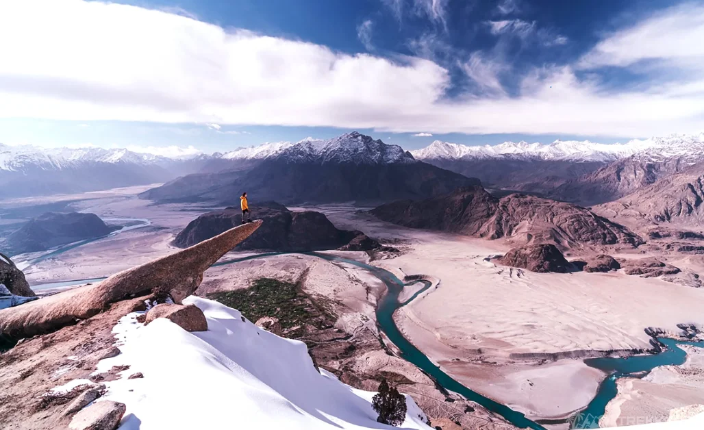
Are you a thrill-seeker hiker? If you’re, you definitely know about the iconic Trolltunga rock in Norway. A famous hiking destination sight that takes you about 1100 meters above sea level and offers stunning vistas.
Well, we just found out that there’s a Trolltunga in Pakistan as well! Yes, it’s true!
So, how could we miss it? While on our Pakistan tour, after arriving in Skardu and visiting the Kharpocho fort, I, along with my friends, aimed to witness the spectacular view of Skardu from the Marsur rock!
Marsur Rock
Marsur Rock is located just above the city of Hussainabad in Skardu. With a height of 3757 meters (12326 ft) above sea level, the rock requires almost 4 hours of trekking but then provides a spectacular bird’s eye view of the whole of Skardu, including the Kharpocho Fort, Indus River, Hussainabad, Skardu City, and Safranga Cold Desert, all in one frame.
How amazing is that, right?
Discovery of Marsur Rock
Being adventurers, we couldn’t resist witnessing this mesmerizing rock called Marsur Rock. It was discovered in 2017 when a group of explorers shared incredible pictures of this place from Hussainabad, Skardu, Pakistan. It took social media by storm, and since then, climbing this rock has become one of the top best hiking destinations for tourists.
Marsur Rock climbing is now considered as one of the best hikes in Skardu. Situated on a high-angled mountain, the rock is a thrill seeker’s paradise. Hence it has been attracting climbers from all over the world. It is a one-of-a-kind adventure requiring a long, tedious hike of almost 4-5 hours, but it is all worth it for the breathtaking views that await at the top.
Expedition to Marsur Rock
While staying in Skardu, we woke early in the morning to prepare ourselves for the adventurous hike. We started the hike early, as it can take 4-5 hours, and ended the hike before the scorching heat came out. This is the best time to do the uphill hiking of Marsur rock, as advised by experts.
We were all set and ready, had our breakfast, and conserved the energy for the trek ahead. Marsur rock has a grippy surface and steeper track. Therefore, we grabbed our hiking boots, sunglasses, snacks, and plenty of water to handle the upcoming hurdles.
There are a few things to remember before starting this adventure. There will be no mobile signals during the entire journey. As with any adventure sport, Marsur rock climbing is a demanding activity that requires physical fitness; make sure to be in good health before embarking on this. Keep reliable hiking boots, sun-protection cream, and a hat, as the sun can be harsh during return, and have a first-aid kit and safety gear in your backpack. Though it’s a safe climb, preparing and ensuring a secure journey is still important.
We gathered all the prerequisites and fastened our backpacks. We set off on our thrilling adventure and drove to the town of Hussainabad. It is a beautiful small village to the right of Skardu and lies on the route to Shigar.
The trek to Marsur Rock begins in a village called Nala. We parked our vehicle in the village, hired a guide to accompany us, and went to climb the wild Marsur’s rocky realm!
Trek and Hike to Marsur Rock
First, we crossed a bridge, then a beautiful steaming water, and finally saw our uphill track. Without wasting any moment, we started ascending.
The starting track, which can be covered in one hour, is much grassland. It was easy to traverse this path. But slowly, the greenery vanished.
Now we were walking on the rocky land that was turning steep. This is where it was getting tough. The trail offered no shade, and we could feel the heat. The only escape solutions were short breaks and drinking plenty of water to stay hydrated.
Gradually as we moved upward, the air was getting thinner, and walking on rocks in the atmosphere had us short of breath. Fortunately, we had enough water to keep us revived.
One of our friends became languid mid-way. She wanted to quit right away. It was probably because of low glucose levels. It’s normal on such hikes that require long hours of walking without shade or rest. Fortunately, we were all prepared and had enough sweets to energize her again.
Three hours had passed since we started trekking, and during this time, we had been walking on a challenging path with loose rocks. At one moment, we almost got lost, but our guide expertly guided us back on track, and thankfully, we didn’t lose our trekking goals.

Reaching the Top
Finally, after a long effort of 4-hour trekking, we reached the peak point. We reached Marsur Rock. Just when we witnessed the view, all our fatigue and sweat instantly faded away. It felt like paradise, being on top of the world while everything was nestled below. It felt more magnificent than we imagined.
We had the opportunity to capture the best photographs while the scenic 360° panoramic view made a spectacular background. This is where we realized why it’s called a spitting image of Trolltunga. It gave the finest bird’s eye view and unfolded the picturesque Skardu before our eyes.
Spectacular Views from Marsur Rock
The views from the summit are absolutely stunning, with a panoramic view of the surrounding area. All the hard work was worth it! For a rock climber or experienced hiker, the surreal achievement is unmatchable!
It is possible to go camping and stay the night at Marsur Rock. People put up their tents and enjoy stargazing along with the breathtaking view from Marsur Rock under the night sky. We decided to head back before daylight.
Conclusion
The Marsur adventure gave us memories that we’ll treasure forever. It was a test of our strength, but the reward was worth it. It left us with an awe-inspiring view and an unforgettable experience. Undoubtedly, it was a challenging climb, but the jaw-dropping view made a sense of exhilarating accomplishment.
So, if you’re up for an exciting journey in Skardu, climbing Marsur Rock should be the top choice!
To keep reading Maisie and her friends’ Pakistan tour journey, head over to the next blog where they explored the blissful Shigar Valley.


