
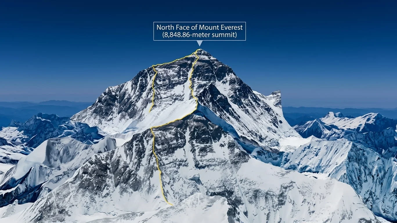
The North Face of Mount Everest is the mountain’s Tibetan flank, rising from the Rongbuk Valley in China’s Tibet Autonomous Region toward the 8,848.86-meter summit. It’s the colder, windier, and more technically demanding of Everest’s two main climbing sides, and it’s also where mountaineering history was made, and lost, long before anyone reached the top from Nepal.
If you’ve landed here wondering what makes this side of Everest different, how to visit it, or why it carries such a fearsome reputation among climbers, you’re in the right place. This guide covers the geography, the route, the danger zones, the history, and the practical details of visiting yourself.
Table of Contents
North Face of Mount Everest at a Glance
| Fact | Details |
|---|---|
| Mountain | Mount Everest (Sagarmatha / Chomolungma / Qomolangma) |
| North Face location | Tibet Autonomous Region, China |
| Everest’s elevation | 8,848.86 m (29,031.7 ft) |
| North Base Camp | Near Rongbuk Monastery, roughly 5,150–5,200 m |
| Advanced Base Camp | About 6,400 m |
| Main climbing route | Northeast Ridge via the North Col |
| Key technical section | The Three Steps, above roughly 8,500 m |
| Famous couloirs | Norton Couloir and Hornbein Couloir |
| First confirmed north-side summit | 1960, Chinese expedition |
| Notable historical figures | George Mallory, Reinhold Messner, Tom Hornbein |
What Is the North Face of Mount Everest?
The North Face is the side of Mount Everest that faces Tibet rather than Nepal. It isn’t a separate peak or a distinct summit; it’s one continuous aspect of the same mountain, defined by the terrain climbers cross on their way up from the north.
People often use “North Face,” “north side,” and “Tibet side” interchangeably, and that’s fine in everyday conversation. Technically, though, the “face” refers to the sweep of rock and ice itself, while the “route” refers to the specific climbing line, mainly the Northeast Ridge, that crosses it. That distinction matters once you start comparing route options, because several different lines (the standard ridge route, the Norton Couloir, the Hornbein Couloir) all cross the same face but differ enormously in difficulty and history.
North Face Quick Fact: The North Face was the first side of Everest ever explored, because Nepal remained closed to foreigners until 1950. Every early attempt on the mountain, starting in 1921, came from Tibet.
Where Is the North Face of Mount Everest?

The North Face sits in Tingri County, within Shigatse Prefecture in Tibet, inside the Qomolangma National Nature Preserve. It rises directly from the Rongbuk Valley, and the classic approach runs from Lhasa along the Friendship Highway through Shigatse and Tingri before turning south toward Rongbuk Monastery.
This puts the North Face on Chinese-administered territory, in contrast to the South Face, which sits across the border in Nepal’s Khumbu region. The two sides are separated by the same summit ridge but feel like entirely different mountains once you’re standing at either base camp.
How High Is the North Face of Mount Everest?
Everest’s summit elevation, 8,848.86 meters (29,031.7 feet) based on the 2020 joint Chinese-Nepali survey, applies regardless of which face you’re discussing. The North Face doesn’t have its own separate height; it’s simply the northern route to that same summit.
What does vary by side is base camp elevation and total vertical gain. North Base Camp sits around 5,150–5,200 meters, roughly comparable to the South Base Camp in Nepal at about 5,364 meters, though the two approaches differ significantly in terrain and access.
What Does the North Face of Everest Look Like?

Photos from Rongbuk show a stark pyramid of dark rock banded with snow and ice, rising almost straight out of a barren, high-altitude plain. Unlike the South Face, where the summit stays hidden behind Nuptse and the Lhotse-Nuptse wall for most of the approach, the North Face is visible in full from the moment you reach Rongbuk Monastery.
The dominant features in any accurate route photo are the Northeast Ridge running toward the summit, the North Col at its base, and the dark line of the Norton Couloir cutting across the upper face. On a clear day, the Three Steps are visible as distinct rock bands near the top of the ridge, the same landmarks that have defined the climbing route since the 1920s.
North Face of Mount Everest Route

The standard northern route follows a well-established sequence of camps and terrain features. Every modern expedition, regardless of operator, moves through essentially the same stages.
North Base Camp and Rongbuk Glacier
Expeditions begin at North Base Camp, near Rongbuk Monastery, at roughly 5,150–5,200 meters. From there, the route follows the Rongbuk Glacier, and its East Rongbuk branch, north toward higher ground. This is the last point with vehicle access and functions as the logistics hub for the entire climb.
Advanced Base Camp
From Base Camp, climbers trek up the East Rongbuk Glacier to Advanced Base Camp (ABC) at roughly 6,400 meters. This stage typically takes several days and includes rotations back to lower elevation for acclimatization, the process by which the body gradually adjusts to reduced oxygen levels.
North Col
Above ABC, the route climbs a steep ice and snow slope to the North Col at approximately 7,000 meters, the saddle between Everest and its neighboring peak, Changtse. This is where sustained technical climbing begins, with fixed ropes (ropes anchored into the mountain that climbers clip into for safety on steep terrain) typically in place through the season.
Northeast Ridge and High Camps
From the North Col, climbers ascend the North Ridge onto the Northeast Ridge, establishing high camps around 7,700 meters and 8,300 meters. Wind exposure increases sharply here, and this stretch is where most weather-related retreats happen.
The Three Steps
Above roughly 8,500 meters, the route crosses the First, Second, and Third Steps, rocky outcrops that force climbers onto exposed, technical terrain within the death zone (the altitude above about 8,000 meters where oxygen is too thin to sustain the human body for long, and physical and mental deterioration begins even with supplemental oxygen). The Second Step is the crux of the route and is covered in detail below.
Summit
Past the Third Step, a final snow slope leads to the summit ridge and the top of Everest at 8,848.86 meters. The descent retraces the same line back through the high camps to ABC.
Route Note: “Face,” “route,” “ridge,” and “couloir” are not interchangeable. The North Face is the broad terrain feature. The Northeast Ridge is the standard climbing route across it. The Norton and Hornbein Couloirs are separate, less-traveled lines that cut through the same face.
Everest North Face Route Map
Picture the standard route as a single vertical line climbing the mountain’s spine:
North Base Camp → Rongbuk Glacier → Advanced Base Camp → North Col → North Ridge → Northeast Ridge (high camps) → Three Pinnacles → First Step → Second Step → Third Step → Summit
Two historic variant lines branch off this route rather than following it: the Norton Couloir, which cuts diagonally across the face below the ridge, and the Hornbein Couloir, a narrower gully on the far side of the summit pyramid. Both were pioneered as alternatives to the exposed ridge crest, and both later became famous descent lines rather than ascent routes, covered in the skiing and snowboarding section below.
Major Features of the North Face
North Col
The North Col is the icy saddle at roughly 7,000 meters connecting Everest to Changtse. It’s the gateway to the upper mountain and one of the more avalanche-prone sections of the climb, which is why fixed ropes and careful timing matter here.
Northeast Ridge
This is the backbone of the standard route, running from the North Col to the summit and hosting the Three Steps. It carries more sustained wind exposure than the equivalent South Col route on the Nepal side.
Three Pinnacles
Lower on the ridge, around 7,800–8,200 meters, sit three steep rock towers that early expeditions found nearly impassable. Most modern climbers bypass the Pinnacles by traversing slightly below them, since a direct crossing has historically produced a disproportionate number of accidents.
First, Second, and Third Step
The First Step, around 8,560 meters, is a rocky obstacle that slows traffic and creates bottlenecks. The Second Step, near 8,600–8,610 meters, is the route’s defining technical challenge, a near-vertical rock band. A Chinese expedition installed a fixed aluminum ladder here in 1975, which has been maintained and periodically replaced ever since; before that, the 1960 Chinese team is reported to have crossed it using a human-ladder technique, with one climber standing on a teammate’s shoulders. The Third Step is shorter and less demanding, serving mainly as the final barrier before the summit snowfield.
Norton Couloir
Named for British climber Edward Norton, who reached roughly 8,573 meters along this line in 1924 without supplemental oxygen, the couloir offers a direct line up the face that avoids the ridge’s technical steps entirely. It’s steep and exposed but free of the Second Step’s rock climbing, which is why it later became the preferred descent line for the first snowboard descent of Everest.
Hornbein Couloir
Discovered during the 1963 American Mount Everest Expedition by Tom Hornbein and Willi Unsoeld, this narrow gully on the far side of the summit pyramid is steeper and more committing than the Norton Couloir, with sections reported between roughly 40 and 55 degrees. It has claimed at least one life among those who’ve attempted to descend it and remains one of the most serious lines on the mountain.
Is the North Face of Everest Harder Than the South Face?

Generally, yes. Most climbers and guides consider the North Face the more technically demanding and logistically riskier of Everest’s two standard routes, though “harder” depends heavily on which factor you weigh most.
| Factor | North Face (Tibet) | South Face (Nepal) |
|---|---|---|
| Technical terrain | Rock steps above ~8,500 m (Second Step) | Khumbu Icefall, less rock climbing near the summit |
| Weather exposure | Colder, windier, more exposed ridge | Somewhat more sheltered approach |
| Base camp access | Reachable by road | Multi-day trek from Lukla |
| Rescue options | Ground evacuation only | Helicopter rescue possible at lower elevations |
| Infrastructure | Fewer fixed camps, less commercial support | More established guiding infrastructure |
| Crowding | Historically less congested | Higher traffic, especially in peak season |
| Route character | Sustained technical climbing near the summit | Icefall danger concentrated lower on the route |
Neither side is easy, and experienced climbers generally describe the difference as a trade of risks rather than a simple harder-versus-easier comparison. For broader context on how Everest compares with the world’s other great 8,000-meter peak, see our guide to K2 vs Mount Everest.
The South Face’s biggest hazard is arguably the Khumbu Icefall, a constantly shifting maze of crevasses and seracs (unstable ice towers) that climbers must cross repeatedly. The North Face avoids that specific danger but replaces it with sustained high-altitude rock climbing and weather that can turn severe with less warning. Neither side is easy, and experienced climbers generally describe the difference as a trade of risks rather than a simple harder-versus-easier comparison.
How Difficult Is the North Face of Mount Everest?
These factors don’t act in isolation. They compound: extreme cold slows movement, slower movement means more time exposed to wind and altitude, and more time at altitude accelerates fatigue and impaired judgment at exactly the point in the climb, above 8,000 meters, where technical rock climbing demands the most precision.
Extreme Altitude
Most of the upper route sits in the death zone, where the body cannot acclimatize and slowly deteriorates regardless of fitness. Supplemental oxygen is standard practice for the large majority of climbers on this side. That extreme-altitude environment is very different from a standard trekking experience such as the K2 Base Camp trek, where visitors can experience the Karakoram without attempting an 8,000-meter summit.
Cold and High Winds
The North Face is more exposed to the jet stream than the South Face, and temperatures near the summit routinely drop to around -20°C or lower during the spring climbing window, with wind chill making conditions feel far worse. Storms can develop with limited warning.
Technical Rock and Ice
The Second Step requires rock climbing skill at an altitude where every movement costs disproportionate energy. Climbers rely on fixed ropes and the maintained ladder to move through this section safely; without them, this stretch would be far beyond the ability of most Everest climbers.
Exposed Terrain
Long stretches of the Northeast Ridge offer little shelter from wind or rockfall, and the traverse near 8,000 meters is regularly cited by climbers as one of the most demanding parts of the route, physically and psychologically.
Limited Rescue Options
Unlike the South Face, where helicopters can reach relatively high elevations for emergency evacuation, the North Face has no equivalent option above Base Camp. Rescue above Advanced Base Camp depends on other climbers and ground teams, which extends response times significantly in a crisis.
History of the North Face of Mount Everest
The North Face was the first side of Everest ever explored by Western mountaineers, simply because Nepal remained closed to foreigners until 1950.
| Year | Event |
|---|---|
| 1921 | First British reconnaissance expedition maps the Rongbuk approach |
| 1922 | British team reaches a new high-altitude record on the mountain |
| 1924 | George Mallory and Andrew Irvine disappear near the summit |
| 1960 | Chinese expedition achieves the first confirmed north-side summit |
| 1963 | Tom Hornbein and Willi Unsoeld discover and climb the Hornbein Couloir |
| 1975 | A Chinese expedition installs the first fixed ladder on the Second Step |
| 1980 | Reinhold Messner makes the first solo ascent without supplemental oxygen |
| 1999 | Mallory’s body is found on the North Face |
George Mallory and Andrew Irvine
Mallory and Irvine set off for the summit on June 8, 1924, and were last sighted by teammate Noel Odell climbing near one of the rock steps on the Northeast Ridge before clouds closed in. Whether they reached the summit, 29 years before Edmund Hillary and Tenzing Norgay’s confirmed 1953 ascent, remains one of mountaineering’s enduring mysteries. Mallory’s body was found in 1999 by a research expedition searching the North Face, but it offered no definitive answer to the summit question. Irvine’s body, and the camera the pair reportedly carried, have never been recovered, so the question remains genuinely unresolved rather than leaning one way or another.
The First Confirmed North-Side Ascent
In 1960, a Chinese expedition that included Wang Fuzhou, Gonpo, and Qu Yinhua became the first climbers confirmed to summit Everest from the north. Some Western climbers initially met the claim with skepticism due to a lack of summit photography, and accounts describe the team crossing the Second Step using a human-ladder technique rather than modern climbing aids. It’s now widely accepted as the first successful north-side ascent.
Famous Climbers and Expeditions on the North Face
Beyond Mallory and the 1960 Chinese team, several individuals shaped how the North Face is climbed today. Edward Norton pushed to roughly 8,573 meters in 1924 without oxygen, giving his name to the Norton Couloir. Tom Hornbein and Willi Unsoeld’s 1963 traverse from the West Ridge into the Hornbein Couloir remains one of the boldest route choices in Everest history. Reinhold Messner’s solo, oxygen-free ascent in 1980 is still regarded as one of the great individual achievements in mountaineering, proving the summit was reachable without a large support team or bottled oxygen. Everest’s history is part of a broader story of high-altitude mountaineering, including the eventual first winter ascent of K2.
Everest North Base Camp and Rongbuk
North Base Camp sits near Rongbuk Monastery at roughly 5,150–5,200 meters and is reachable by vehicle, a logistical advantage over the South Base Camp in Nepal, which requires several days of trekking from Lukla. Rongbuk Monastery itself, founded in 1902, is among the highest monasteries in the world and sits close enough that the summit is visible from its grounds on clear days.
From Base Camp, the Rongbuk Glacier leads toward Advanced Base Camp, following the same corridor expeditions have used since the 1920s. This road access is one reason the North Face route has historically appealed to expedition operators despite its harsher conditions: it removes the multi-day approach trek the South Face requires.
How to Visit the North Face of Mount Everest

Visiting the North Face as a sightseer, rather than a climber, is genuinely possible and doesn’t require mountaineering experience. Most travelers fly into Lhasa, spend a couple of days acclimatizing, then travel overland via Shigatse and Tingri toward Rongbuk.
Important for Visitors: The historic tent-camp base camp area, at roughly 5,150–5,200 meters, has been closed to general tourists since around 2018–2019 for environmental protection reasons. Most current visitors reach a designated viewing area near Rongbuk Monastery instead, which still offers a direct, unobstructed view of the North Face. Rules around exactly how far tourists can travel have shifted more than once in recent years, so confirm current access with a licensed operator before finalizing a trip.
A few requirements generally apply, though exact names and processes can change and should be verified with a licensed agency before booking:
- A valid Chinese visa
- A Tibet Travel Permit
- An additional permit for restricted areas, sometimes referred to as an Aliens’ Travel Permit
- Travel with an approved agency or licensed guide, since independent foreign travel in this part of Tibet is not permitted
Climbers pursuing an actual summit attempt need a separate mountaineering permit issued through Chinese and Tibetan mountaineering authorities, a process involving substantially more paperwork, cost, and lead time than a sightseeing visit.
Climbing Note: Access to Everest’s north side for foreign climbing expeditions has fluctuated in recent years and has been reported closed for at least the 2026 season, following an unrelated regulatory dispute in the region. This kind of restriction has historically been temporary and season-specific rather than permanent, but anyone planning an expedition should confirm current status directly with the China-Tibet Mountaineering Association or a licensed operator well before booking.
Total cost for a North Face expedition varies considerably depending on permits, the operator chosen, the level of Sherpa and logistical support, supplemental oxygen, personal equipment, transportation, and insurance, so it’s worth treating any specific figure you see elsewhere as a starting point for research rather than a fixed number.
Best Time to Visit the North Face of Everest
For sightseeing and photography, late April through early June and again from September into October generally offer the clearest skies and calmest winds. Winter is bitterly cold and not worth attempting for most travelers, while the summer monsoon brings cloud cover that can obscure the mountain for days at a time.
For climbing, the window narrows considerably. Spring remains the primary season, when the jet stream typically lifts off the summit for a short stretch, creating a viable weather window for a summit push. It’s worth separating these two timelines clearly: a good sightseeing trip to Rongbuk doesn’t require the same narrow weather window that a summit attempt does, and conditions genuinely can vary year to year.
Skiing and Snowboarding the North Face of Everest
The North Face has a descent history that’s distinct from, and often confused with, its climbing history. Getting the details right matters, because the first snowboarder and the first skier to descend the face used different routes and were separated by more than two decades.
The First Snowboard Descent
French snowboarder Marco Siffredi made the first confirmed continuous snowboard descent from Everest’s summit on May 23, 2001, riding the Norton Couloir down to Advanced Base Camp. He’d originally hoped to ride the steeper Hornbein Couloir, but insufficient snow cover forced the reroute. The following year, in September 2002, Siffredi returned to attempt a snowboard descent of the Hornbein Couloir and disappeared during the attempt; his body has never been recovered.
Ski Descents of the Hornbein Couloir
The Hornbein Couloir remained unskied for decades after Siffredi’s death, earning a reputation as one of the most sought-after and dangerous descent lines in high-altitude skiing. Reports indicate American skier Jim Morrison completed the first ski descent of the Hornbein Couloir in October 2025, covering thousands of vertical feet in a matter of hours, a milestone that finally answered a question mountaineers had been asking since Siffredi’s era. Because this is a very recent record, exact timing and technical details are worth double-checking against a current primary source before publication.
Route Note: Siffredi’s record is a snowboard descent of the Norton Couloir. Morrison’s record is a ski descent of the Hornbein Couloir. These are two different achievements, on two different lines, more than two decades apart, and should never be merged into a single claim.
Why Is the North Face So Dangerous?
The North Face’s danger comes from several factors compounding at once rather than any single hazard. Extended time in the death zone degrades judgment and physical capacity regardless of experience. Add extreme cold, high winds, technical rock climbing at the Second Step, and rescue options limited to slow ground evacuation, and the margin for error narrows considerably compared to routes with more infrastructure. Weather windows can close quickly, and the exposed nature of the Northeast Ridge leaves little shelter if conditions turn while a team is committed to the upper route.
Frequently Asked Questions
What is the North Face of Mount Everest?
It’s the northern side of Mount Everest, located in Tibet, China, facing the Rongbuk Valley. It’s one continuous aspect of the same mountain rather than a separate peak, used by climbers approaching from the north rather than from Nepal.
Where is the North Face of Mount Everest located?
It sits in Tingri County, Shigatse Prefecture, within the Tibet Autonomous Region of China, inside the Qomolangma National Nature Preserve.
How high is the North Face of Mount Everest?
The summit it leads to stands at 8,848.86 meters (29,031.7 feet). The North Face itself doesn’t have a separate elevation; it’s the route to the same summit reached from the south.
Is the North Face of Everest harder than the South Face?
Most climbers and guides consider it harder overall, largely due to colder temperatures, stronger winds, more technical rock climbing at the Second Step, and limited rescue options. The South Face carries its own major hazard in the Khumbu Icefall, so the comparison depends on which risks matter most to a given climber.
Has anyone climbed the North Face of Mount Everest?
Yes. A Chinese expedition achieved the first confirmed north-side summit in 1960, and numerous expeditions have summited via this route since, including Reinhold Messner’s solo, oxygen-free ascent in 1980.
What is the route up the North Face of Everest?
The standard line runs from North Base Camp through Advanced Base Camp to the North Col, then up the North and Northeast Ridges past the Three Steps to the summit.
What is the hardest part of the North Face of Everest?
The Second Step, near 8,600 meters, is widely regarded as the technical crux. That said, the broader stretch above 8,000 meters, with its wind exposure and altitude effects, is arguably just as demanding in a different way.
Where is Everest North Base Camp?
It’s located near Rongbuk Monastery in Tibet, at approximately 5,150–5,200 meters.
Can tourists visit North Base Camp?
Sightseers can generally reach a viewing area near Rongbuk Monastery with the required permits and a licensed guide. The historic tent-camp base camp itself has been closed to general tourists since around 2018–2019, so it’s worth confirming exactly how close current access allows you to get before planning a trip.
What is the best time to visit the North Face of Everest?
Late April to early June and September to October generally offer the clearest conditions for visiting or photography. Climbing season is narrower and depends heavily on the spring weather window.
Who was Marco Siffredi?
A French snowboarder who made the first confirmed continuous snowboard descent from Everest’s summit, via the Norton Couloir, on May 23, 2001. He disappeared in 2002 while attempting a snowboard descent of the Hornbein Couloir.
Who first skied down the North Face of Everest?
Reports credit American skier Jim Morrison with the first ski descent of the Hornbein Couloir in October 2025, a different line and a separate record from Siffredi’s snowboard descent of the Norton Couloir.
What are the Three Steps on Everest?
Three rocky sections on the Northeast Ridge above roughly 8,500 meters. The Second Step is the most technically demanding, aided by a fixed ladder installed in 1975, while the First and Third Steps are comparatively easier obstacles.
What are the Norton and Hornbein Couloirs?
Both are steep gullies on the North Face used as alternative lines to the exposed ridge route. The Norton Couloir was pioneered by Edward Norton in 1924, and the Hornbein Couloir was discovered by Tom Hornbein and Willi Unsoeld in 1963. Both later became notable descent routes for snowboarding and skiing.


This Post Has 6 Comments