
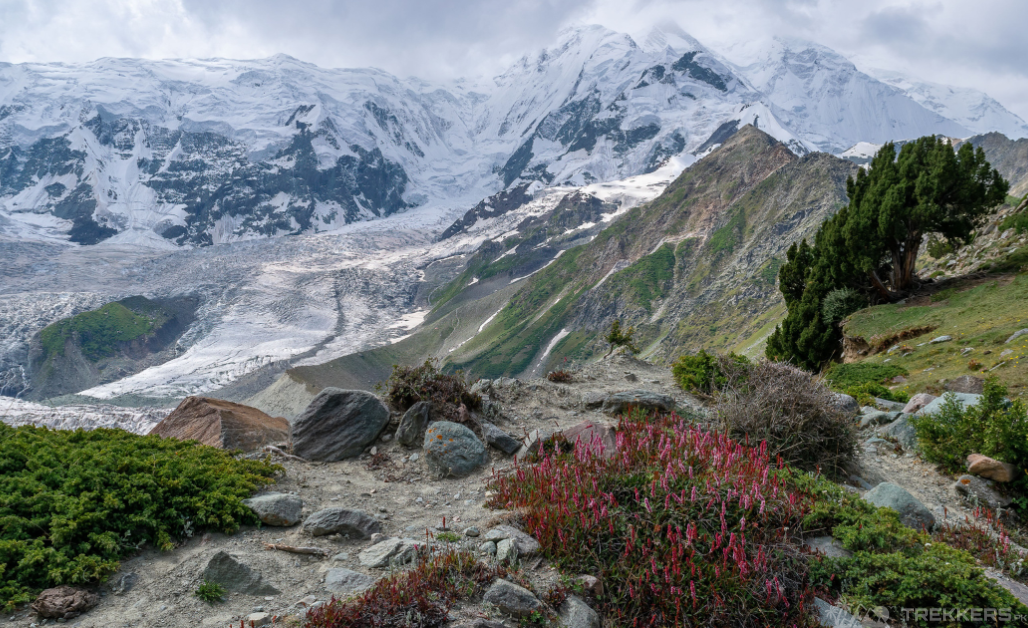
The Rakaposhi trek and Hon Pass is one of the most challenging but rewarding treks in the world. Located in the Karakoram Mountains of Pakistan, this trek offers stunning views of towering peaks, glaciers, and alpine meadows. And finally, leads you to the 27th-highest peak in the world, Rakaposhi.
The jaw-dropping peak that stands proudly at an elevation of 7,788 meters. Rakaposhi is known to be one of the most beautiful mountains in the world.
Trekking is considered to be a risky and difficult sport but by being prepared for what’s about to come and having all the necessities, you can have a thrilling trip to the destination you have always wanted to visit.
These are some tips and answers to questions regarding the Rakaposhi trek and Hon Pass. Hopefully, they will prepare you better for this exciting trek!
What are the necessities you need to bring along this trek?
One of the most frequently asked questions about any trek is what clothes and gear we need to pack for the journey. The most integral factors to consider while packing clothes and other items are safety, comfort and versatility. So, some of the necessary items that you need to pack are:
Clothes:
- Long-sleeved and half-sleeved shirts (preferably made of merino wool and avoid cotton).
- Warm pants of your preference (something made of quick drying materials).
- Fleece jacket, waterproof and windproof jacket, gloves, and socks.
- Comfortable footwear, hiking boots and slippers.
Gear And Other Necessary Items:
- A battery powered torchlight.
- GPS and trek maps.
- Sturdy hiking poles.
- A Swiss knife.
- A waterproof and insulating sleeping bag.
- A day backpack or a bag pack that can carry all your items (preferably waterproof)
- Sunglasses (for protection from the UV rays)
- A Power bank and excess batteries for your camera.
- Toiletries (sanitizer, sunscreen, shampoo, toilet paper, wipes, toothbrush and toothpaste)
- Painkillers and emergency medicines
- Band-aid.
Snacks:
Carrying snacks like protein bars, chocolates, dry fruits, energy drinks like Gatorade and most importantly, water will cause a lot of convenience to this trip. Having compact and calorie-rich items will make your trip easier while trekking.
Why should you consider going to the Rakaposhi base camp and hon pass? Is it comparatively difficult from other treks?
The reason why I chose this trek was because of the breathtaking views and landscape and the sense of adventure the whole trip offered. Being an adrenaline junkie and a visually inclined person, this place has always been on my bucket list.
The multi-day trek is a little rocky and unsteady starting from Minapin (2,814 m). Firstly, you will have to trek for 4 to 5 hours through the lively Minapin Village crossing the enchanting Minapin river. The stepped path also gives a wide view of the Minapin Glacier. Secondly, from Minapin you trek to Hapakun in 3 to 4 hours. And finally, from the thick forest, you reach a ridge where you can view the majestic Rakaposhi mountain and the psychedelic Minapin glacier from afar.
That view alone is worth the whole trek but that is not the destination to hold your breath for as you get to visit the vibrant Ultar meadows and Hon pass. The trek gets tricky at some points like at the end of Minapin until you reach the forest while trekking to Hapakun but that is the only point where the trek gets steep and rocky but other than that the trek’s difficulty is moderate.

Is a tour guide necessary to help you navigate?
Having a tour guide is incredibly helpful while on this trip. They provide valuable insights, ensure safety and enhance the overall experience. While the trek being risky at some points, a tour guide is highly recommended to ensure that you have a safe trip. Other than that, it is vital to travel with a government-licensed guide.
How much is the whole trip going to cost?
The whole trek has been organized very meticulously and the price for each plan has been set just right to give a clear idea about the budget. Rest assured that every penny you pay is used only to make your experience better and better and worthwhile.
So, depending on the plan you choose, the prices are:
- For a 10-day all-inclusive trip to Hon pass and Rakaposhi Base camp the prices will be 1,165 USD.
- For a 12-day all-inclusive trip to Hon pass and Rakaposhi Base camp the prices will be 1,310 USD.
- For a 14-day all-inclusive trip to Hon pass and Rakaposhi Base camp the price will be 1,455 USD.
How long will the trip be?
Each plan is devised in a way to save as much of your travel time as possible so that you can enjoy other activities like sightseeing, socializing with locals and making the most of your journey. An overview of what you can expect from your Rakaposhi trek is given below:
DAY 1:
Includes the arrival at Islamabad and city tour of Islamabad and Rawalpindi.
DAY 2:
Drive from Islamabad to Naran (279 km) followed by a lunch break and then resume towards Chilas (113.3 km)
DAY 3:
From Chilas the trek continues to Minapin which takes about 5-6 hours on average. It includes a stop at Thalchali; the junction point of the three great mountain ranges (Himalayas, Karakoram, and Hindukush).
DAY 4:
After a 4–5-hour trail to Hapakun you reach Minapin where you will pass through the village there and also will be able to see the Minapin glacier.
DAY 5:
From Minapin, trek for 3-4 hours to reach Rakaposhi base camp that is through a forest with a view of Diran.
DAY 6:
Excursion to Diran peak base camp (Altitude 3,650 m) and trek back to Hapakun.
DAY 7:
Trek back to Minapin village in 3 hours and drive back to Karimabad.
DAY 8:
From Karimabad trek to Ultar meadows in 4 to 5 hours starting from Baltit fort and ending at the camp trek of the Ultar peak.
DAY 9:
Excursion to Hon pass (4,257 m) on a steep ridge above Ultar and then back to Ultar meadows.
DAY 10:
Trek down from Ultar meadows to Karimabad in 3 to 4 hours for a night-stay in a hotel there.
DAY 11:
Visit to Baltit fort, Altit fort and the Altit village.
DAY 12:
Drive to Naran 355 km via Babusar pass 4,173 m
DAY 13:
Drive to Islamabad 279 km, and then have a visit to Taxila museum and other historical places.
DAY 14:
Fly back home.
I hope these tips, learned through many failures and successes of my personal expedition of Rakaposhi trek, will help you in your journey and will further make a difference in your adventurous trips.
Although there will be some points where you will hesitate, but the magnificent view will make you fall in love with the astonishing beauty of this thrilling trip.


This Post Has One Comment