
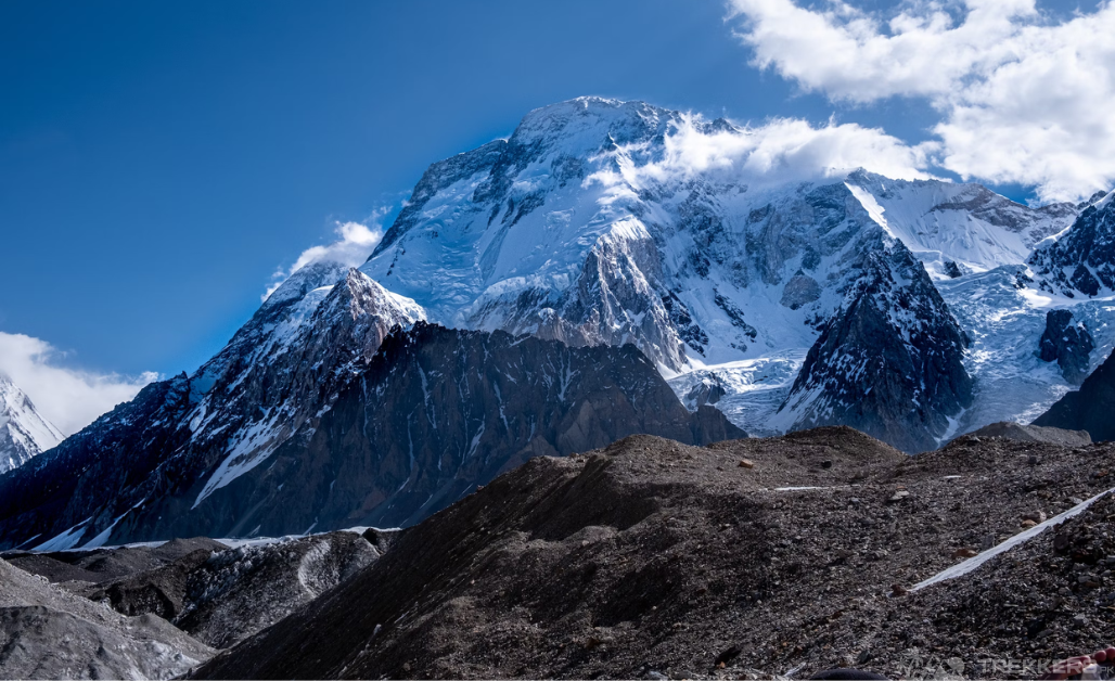
Broad Peak is the 12th highest peak in the world, with an impressive height of 8,051 meters above sea level. The mighty peak dwells in the Karakoram Range in northeastern Pakistan, being a neighbor to the 2nd highest peak and savage mountain, K2.
Witnessing this peak was always my dream. Though it is often overshadowed by the renowned K2, I intensely desired to witness this summit from the closest. A fine breadth of mountain splendor, a peaked ridge almost 2 km long, the prominent feature similar to my home country’s, Switzerland’s Breithorn mountain that translates to ‘broad horn.’ With a keen interest in mountaineering, this just makes Broad Peak more fascinating to me.
To make my dream come true, my friends and I planned a trip to Pakistan and explore the Gilgit-Baltistan region. The trek to Broad Peak base camp was at the top of our bucket list. And though the expedition was challenging, it was definitely rewarding!
Here’s the journey of my lifetime, where I witnessed the massive eight-thousanders in a venturesome trekking adventure!
Expedition to Broad Peak, Pakistan
The journey started as we took a flight from Switzerland and reached Islamabad, the capital city of Pakistan. And from here, the destination was a long way. I still had to wait for 17 days to reach the Broad Peak base camp and gaze at the dreamy peak.
The tour company that we contacted accompanied us at the Islamabad airport and then helped us to the hotel. After a long flight, we had some rest and then met our fellow local adventurers during lunch. It couldn’t have been better to accompany like-minded people who have the same intense desire.
There are two routes to reach Broad Peak base camp, one from Askole and the other one from Gondogoro La Pass. Gondogoro, the high mountain pass with an elevation of 5585 meters, is a technically challenging climb. Therefore, our guide decided to initiate from Askole Valley.
Reaching Askole
Askole, the last settlement of Pakistan in the Shigar district. To access it, we were carried in jeeps for a long 6-7-hour journey through the breathtaking city of Skardu. Witnessing the Sarfranga Cold Desert and the picturesque valley of Shigar stimulated this bumpy drive.

When we reached Askole, I realized the long ride was just the start of a dreamy venture. Askole, the gateway to the majestic mountains, was truly a spectacular remote region. Now, I was even more excited to witness the intact beauty of the Karakoram ranges that was obscured from us.
We had a camp night here in the raw surroundings. This was our first night sleeping in tents and getting ready to live this lifestyle. The next morning was all about excitement as we geared up for our trek. The guide took care of porters and luggage while we stretched our bodies to warm up for the multi-day strenuous trek.
Start of the Trek
The initial trek was straightforward as we walked on well-leveled ground along a river. However, the burning sun was the only hurdle. Along the way, we encountered an Army checkpost and had some necessary checking. Our first campsite was Joula, and it took around 6-7 hours to reach it.
The Joula campsite was a good start, with pleasing views of Bakhordas peak (5809 meters). Our next campsite was Paiju, and we started our 7-hour trek towards it. This trek was relatively hard, with a mix of ascending and descending routes. After the uphill hiking through rugged terrain, we reached Urdukus. It was the start of Baltoro Glacier, one of the largest glaciers in the world. Eyeing at the Trango towers from here felt exemplary.
After the first night camping on the glacier, we woke up and started walking towards Goro II. As I trekked forward from here, the weather was turning into a challenge. The cold breezes were giving us shivers even when in layers. We had a lunch stop at Goro I, where we could have a sight of the staggering Masherbrum (K1). At this point, I was totally satisfied with the decision to visit this aesthetic paradise.

Concordia
Camp night at Goro II is a real test for everyone’s endurance when the challenging weather at such a high altitude of 4285m doesn’t give an easy time. However, this tough trial led us to the most awaited place, Concordia. The confluence of Baltoro and Godwin-Austen glaciers, and the only place in the world with a view of K2, Broad Peak, Gasherbrum I, and Gasherbrum II all together in one frame!
Reaching here at an altitude of 4,691 meters, I was completely awe-struck as I had the first glimpse at the Broad Peak and the mighty K2. The greatest grandeur of the world was a sight to behold!
But my destination was still at some distance. I wanted to witness the Broad Peak from the closest. We camped in Concordia while the giants surrounded us like our guardians. It felt completely idyllic.
As the sun slowly rose over Baltoro glacier and the light gleamed at these eight-thousanders, we had our jaws dropped. All the arduous expeditions definitely paid for this view and magical moments. Some of our group members were elated at this accomplishment and retraced their steps back to Askole, while my group, along with some high-altitude porters and our guide, headed forward to Broad Peak base camp.
Translated to ‘Falchan Kangri’ in the local Balti language, the Broad Peak is named for its immense bulk and breadth at the top. The peak is located adjacent to K2 and near Gasherbrum IV. Mostly, it is used as a stepping stone for the seekers looking to conquer K2 because climbing this peak is comparatively easier and safer.
From Concordia, we couldn’t judge the distance to Broad Peak base camp because it looked too near. But it took us a 4-hour walk on the medial moraine of the Godwin-Austen Glacier to reach Broad Peak base camp (5000m).

Broad Peak Base Camp
Finally, the moment I was waiting for to witness the majestic peak from the closest. The summit ridge looked spectacular and uniquely identified this unfathomed mountain. It has three separate summits: the main summit, 8,047 meters; the central summit, 8,016 meters; and the north summit, 7,550 meters. The campsite was small, with a few tents and a few amenities. It was a great place to acclimatize to the altitude and enjoy the views of Broad Peak and the surrounding mountains.
The sense of accomplishment and a rush of emotions ran inside us. All the effort and the long, tedious journey was to be in this part of the world, where we stand in front of the noble Broad Peak.
At our opposite was the savage mountain of K2. How could we miss that?
We made the most of the day and trekked forward to the K2 base camp. The mighty K2, with a height of 8,611 meters, towered over us. And then next, we saw the Gilkey Memorial and paid homage to the departed souls who lost their lives trying to conquer K2. After wandering around and interacting with the aspiring climbers, we headed back to Broad Peak base camp and stayed the night.
Start of A New Adventure
The first rays of dawn at Broad Peak base camp hinted at a new adventure for us. Our team decided to have an extensive stay and trek to Chogolisa – the Bride Peak!
So, delve into the next blog to read that exhilarating journey:


This Post Has 2 Comments