
Table of Contents
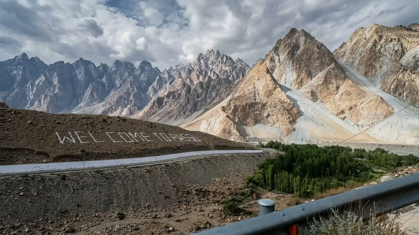
The Passu Cones are a row of jagged limestone peaks, shaped like sharp needles, rising above Passu village in Upper Hunza, Gilgit Baltistan. They reach an elevation of 6,106 meters (20,033 feet) and sit directly beside the Karakoram Highway, so you don’t need to trek to see them. This guide covers the location, distances from major cities, the best viewpoints, and what else to know before visiting.
What Are the Passu Cones?
The Passu Cones are a cluster of sharp rock spires in the South Ghujerab Mountains, a subrange of the Karakoram. The formation is known by three names that all refer to the same peak: Passu Cones, Tupopdan, and Passu Cathedral.
Tupopdan is generally believed to come from a Wakhi phrase, though sources differ on the exact meaning, translating it as either “sun drenched mountain” or “hot rock,” the latter a reference to how quickly snow tends to shed off the south facing slopes. Passu Cathedral is a more recent, descriptive nickname used by climbers and photographers, inspired by how the ridge resembles a row of spires against the sky.
What sets the Cones apart isn’t height alone. Several Karakoram peaks are taller. It’s the shape: the ridge breaks into a row of distinct, sharply defined pinnacles rather than a single rounded summit, which is unusual for a peak in this range and is largely what makes it so photogenic.
Where Are the Passu Cones Located?

The Passu Cones sit above Passu village, in the Gojal Valley of Upper Hunza, within the Hunza District of Gilgit Baltistan, Pakistan. The peaks rise on the northern side of the Hunza River and are visible from the Karakoram Highway (KKH) as it runs between Gulmit and Passu.
The geographic hierarchy, from most specific to broadest, looks like this:
Passu Cones, Passu village, Gojal Valley, Upper Hunza, Hunza District, Gilgit Baltistan, Pakistan
This matters for planning because “Hunza” is often used loosely to describe the entire valley, from Karimabad in the south to Sost near the Chinese border. Passu sits well north of Karimabad, closer to Sost than to central Hunza, which changes travel time estimates considerably.
How High Are the Passu Cones?

The Passu Cones reach 6,106 meters (20,033 feet). This figure is documented in Wikipedia’s Tupopdan entry and repeated across most reliable travel sources.
A common point of confusion is mixing up the Passu Cones with Passu Sar, a separate, taller mountain visible from roughly the same area.
| Peak | Elevation | Notes |
|---|---|---|
| Passu Cones (Tupopdan) | 6,106 m (20,033 ft) | The jagged spires visible from the KKH, first climbed in 1987 |
| Passu Sar | 7,478 m (24,534 ft) | A separate, higher peak in the same general vicinity |
If a source quotes 7,478 meters for the Passu Cones, it’s actually describing Passu Sar. The two are distinct summits, and conflating them is a common error in Passu related content online.
How to Get to Passu Cones

Reaching Passu means traveling the Karakoram Highway, a route generally regarded as one of the more scenic road journeys in the region. There’s no airport in Passu itself, so every route eventually joins the KKH.
From Islamabad: The overland journey takes roughly 16 to 18 hours by road, usually broken into an overnight stop in Chilas, Gilgit, or Karimabad rather than attempted in one push.
From Gilgit: Passu is about 4 to 5 hours by road, following the KKH north through Nagar and Hunza. Flying from Islamabad to Gilgit (around 1 hour, weather permitting) can cut down total travel time, though these flights are often delayed or canceled due to mountain weather.
From Karimabad (central Hunza): Passu is around 1 to 1.5 hours north by car, making it a manageable day trip if you’re already based in Karimabad or Aliabad.
From Skardu: There’s no direct highway between Skardu and Hunza. Most travelers go via Gilgit, which adds several hours to the journey. Some operators offer alternative routes through nearby valleys, but these aren’t standard tourist routes and should be confirmed locally before relying on them.
By private vehicle versus public transport: A private car or hired jeep is the more practical option. Public vans run along the KKH between Gilgit and Sost, but they don’t typically stop on demand at scenic viewpoints, which matters for a destination people visit largely to photograph.
Passu Cones Distance From Major Places
Approximate road distances and drive times, based on standard KKH routing:
| Starting Point | Approx. Distance | Approx. Drive Time | Notes |
|---|---|---|---|
| Karimabad, Hunza | ~50 km | 1 to 1.5 hours | Most common day trip base |
| Gilgit | ~150 km | 4 to 5 hours | Full KKH route |
| Islamabad | ~600+ km | 16 to 18 hours | Usually split over 2 days |
| Attabad Lake | ~30 km | 30 to 45 minutes | Along the same highway |
| Gulmit | ~10 to 15 km | 15 to 20 minutes | Closest sizable village |
| Sost | ~50 km | 1 to 1.5 hours | Border town, farther north |
Treat these as planning estimates rather than fixed figures. Road conditions, landslides, and seasonal closures on the KKH can add hours to any of these journeys, particularly during or after monsoon rains.
Best Viewpoints for Passu Cones
You don’t need a specific vantage point to see the Cones; they’re visible along a fairly long stretch of the highway. That said, a few spots tend to offer better compositions than others.
The KKH roadside near Passu village. This is the view most visitors get by default, with the Cones rising across the Hunza River, often with the river itself in the foreground.
Rainbow Bridge area. North of Passu, near the smaller suspension bridge painted in rainbow colors, the angle opens up and is often mentioned as offering a wider, more direct view of the ridge, though this can vary with the season and light.
Hussaini Suspension Bridge vicinity. The bridge is the main draw here, but the Cones are visible in the background from several points along the approach, making it easy to combine both stops.
Roadside cafés along the KKH. A handful of terraces near Passu are positioned toward the view, letting you photograph the Cones over a meal instead of from the highway shoulder.
For photography, golden hour (the period shortly after sunrise and before sunset) is when the pale limestone tends to pick up a warm gold color, which is the shot most visitors are after.
Do You Need to Hike to See Passu Cones?
No. The main view of the Passu Cones is visible directly from the Karakoram Highway, with no hiking required. This is worth stating plainly, because “seeing,” “hiking near,” and “climbing” the Cones are three different things.
Seeing the Cones means standing at a roadside viewpoint or café terrace. No particular fitness or equipment is needed.
Hiking around Passu usually refers to walks toward Passu Glacier or Borith Lake, both a few hours round trip on established trails, offering closer views of the surrounding landscape rather than the summit itself.
Climbing the Passu Cones (Tupopdan) is a technical mountaineering objective, first summited in 1987 by Andy Cave and John Stevenson via the Northeast Ridge. It remains a serious undertaking attempted by relatively few climbers each year, not a casual trekking route. If someone mentions “climbing Passu Cones,” they mean a proper mountaineering expedition, not a hike.
Passu Cones Weather and Best Time to Visit
The best time to visit is generally April to October, when the Karakoram Highway is reliably open and the peaks are clearly visible against the sky. Each season offers something different, so the right month depends on what you’re looking for.
Spring (March to May): Cherry blossoms and fresh greenery fill the valley, with mild days and still cold nights. Good for lush foreground color rather than the drier landscape of late summer.
Summer (June to August): The most popular season, with the clearest and most stable weather for road travel and photography. It’s also the busiest period, so expect more traffic and fuller guesthouses.
Autumn (September to November): Golden foliage against the grey limestone spires is a popular combination for photographers, and crowds tend to thin out compared to summer.
Winter (December to February): Passu sits under snow, and the highway can face intermittent closures after heavy snowfall. Winter suits travelers who want a quieter, snow covered landscape and don’t mind extreme cold and limited services.
Don’t expect precise temperature forecasts months in advance. Mountain weather in the Karakoram can shift quickly, so it’s worth checking a short range forecast a few days before you travel rather than relying on seasonal averages alone.
Things to See Near Passu Cones

Passu works well as a base for exploring several nearby landmarks in Upper Hunza, most within a short drive.
- Passu Glacier: A large glacier a short hike from the village, with a moderate 4 to 5 hour round trip trek to a proper viewpoint.
- Batura Glacier: One of the longer glaciers outside the polar regions, visible from certain KKH viewpoints without a dedicated trek.
- Hussaini Suspension Bridge: A rope bridge made of wooden planks over the Hunza River, often described as one of the more precarious pedestrian bridges in the region, and a popular stop paired with Passu Cones photography.
- Borith Lake: A quiet alpine lake reached by a short hike or dirt road drive, known for migratory birds in spring.
- Attabad Lake: A turquoise lake formed by a 2010 landslide, roughly 30 minutes south along the highway, with boating available.
- Gulmit village: A traditional Wakhi settlement with local handicrafts, a quieter alternative base if Passu’s guesthouses are full.
Most travelers combine two or three of these into a single day trip from Karimabad or Passu, rather than trying to cover all of them at once.
Where to Stay Near Passu Cones

Passu village has a small range of guesthouses and modest hotels, with some offering views of the Cones from the room or terrace. Staying in Passu is the more convenient option if you want to catch sunrise or sunset light on the peaks without an early drive.
Staying in Passu: Best for photography timing and a slower pace. Options are simple, mostly small guesthouses run by local families rather than larger hotels, and amenities are limited.
Staying in Gulmit: A short drive from Passu, with a bit more choice in dining and a similarly low key village atmosphere.
Staying in Karimabad: The most developed option, with a wider range of hotels and restaurants, at the cost of a 1 to 1.5 hour drive each way to reach Passu.
Cash is worth carrying wherever you stay. ATMs are scarce to nonexistent in Passu and Gulmit, so it’s worth withdrawing what you need in Gilgit or Karimabad beforehand.
Why Do the Passu Cones Have Sharp Peaks?
The Passu Cones’ shape comes from a combination of tectonic uplift and erosion over time. The Karakoram is one of the more tectonically active mountain systems on Earth, and the underlying rock here is limestone, formed from sediment laid down when the region sat under an ancient sea.
As the range was pushed upward through the collision of the Indian and Eurasian tectonic plates, water and glacial ice worked on the exposed rock over a very long period. Because this limestone tends to fracture and erode unevenly, softer sections wore away faster than the harder ridgelines, leaving behind a row of separated spires rather than a single rounded summit.
Passu Village and the Wakhi Culture
Passu itself is a small settlement in the Gojal Valley, home to the Wakhi community, an ethnic group with roots tracing back to the Wakhan region, now part of Afghanistan. Most Wakhi families in Gojal follow the Ismaili branch of Islam, which places a strong emphasis on education, and the area is often noted for relatively high literacy compared with other rural parts of Pakistan.
Daily life still centers on subsistence agriculture and livestock. Wheat, barley, potatoes, and apricots are common crops, and dried fruit is a winter staple given the harsh season. Many families in the area run small guesthouses offering homemade Wakhi meals, which is often part of the experience of staying here.
Passu Cones FAQs
Where are the Passu Cones located?
The Passu Cones are located above Passu village in the Gojal Valley of Upper Hunza, Gilgit Baltistan, directly beside the Karakoram Highway.
How high are the Passu Cones?
The Passu Cones reach 6,106 meters (20,033 feet). They’re sometimes confused with the nearby Passu Sar, a separate, taller peak at 7,478 meters.
Are Passu Cones and Passu Cathedral the same place?
Yes. Passu Cones, Passu Cathedral, and Tupopdan all refer to the same formation, they’re simply different names used by locals, climbers, and tourism sources.
Are Passu Cones and Passu Sar the same mountain?
No. Passu Cones (Tupopdan) stands at 6,106 meters, while Passu Sar is a distinct, higher peak in the same area at 7,478 meters. They’re often confused because both are visible from similar vantage points.
How far are Passu Cones from Karimabad, Hunza?
Roughly 50 kilometers, or about 1 to 1.5 hours by car, north of Karimabad along the Karakoram Highway.
How far are Passu Cones from Gilgit?
The drive from Gilgit to Passu covers about 150 kilometers and typically takes 4 to 5 hours by road.
How do you get to Passu Cones?
Most travelers reach Passu by road along the Karakoram Highway, either from Gilgit (4 to 5 hours) or as a day trip from Karimabad (1 to 1.5 hours). Flying into Gilgit first can reduce total travel time from Islamabad, though flights are weather dependent.
Do you need to hike to see the Passu Cones?
No. The Passu Cones are visible from the Karakoram Highway and nearby roadside viewpoints, so no hiking is required to see them.
Can you climb the Passu Cones?
Yes, but it’s a technical mountaineering objective rather than a casual trek. The peak was first summited in 1987 and requires proper expedition planning and mountaineering experience.
What is the best viewpoint for Passu Cones?
The roadside area near Passu village offers the classic view with the Hunza River in the foreground, while the Rainbow Bridge area farther north is often mentioned as offering a wider angle on the ridge.
What is the best time to visit Passu Cones?
April to October generally offers the most reliable road access and clearest views. Autumn (September to November) is often favored for photography due to the foliage and thinner crowds.
What is the weather like at Passu Cones?
Summers are mild during the day and cool at night, while winters bring heavy cold and occasional road disruption after snowfall. Weather in the Karakoram can shift quickly, so check a short range forecast before traveling.
What are the best places to visit near Passu Cones?

Passu Glacier, Borith Lake, Hussaini Suspension Bridge, and Attabad Lake are all within a short drive and commonly combined into one day trip.
Where can you stay near Passu Cones?
Passu village has small guesthouses and modest hotels, some with views of the Cones. Gulmit and Karimabad offer additional options with more amenities, at the cost of a longer drive.


This Post Has One Comment