
Table of Contents
The Diamir Face is the northwest face of Nanga Parbat, the 8,126 meter peak in Pakistan’s Gilgit Baltistan region that ranks as the world’s ninth highest mountain. It functions as both a major mountaineering objective and the approach used by trekkers heading to Base Camp, so Diamir refers at once to a face, a valley, a glacier and an approach system, not to a single trail or a single climb.
That combination, a serious high altitude wall on one side and a reachable trekking destination on the other, is what makes the Diamir side worth understanding on its own terms rather than as a footnote to the rest of Nanga Parbat.
Quick Reference
| Feature | Details |
|---|---|
| Mountain | Nanga Parbat, 8,126 meters |
| Global Rank | 9th highest mountain on Earth |
| Face | Diamir Face, northwest aspect |
| Location | Diamer District, Gilgit Baltistan, Pakistan |
| Base Camp Elevation | Approximately 4,200 to 4,250 meters |
| Established Route | Kinshofer Route |
| First Ascent of Diamir Face | 1962, the mountain’s second overall ascent |
| Recent Milestones | New alpine style route in 2025; continuous ski descent from the summit to the end of skiable snow in 2026 |
What Is the Diamir Face of Nanga Parbat?
The Diamir Face rises roughly 3,500 meters from the Diamir Glacier toward the summit ridge. It sits opposite the Rupal Face on the mountain’s south side and is separated from the Rakhiot Face to the north by a long subsidiary ridge system.
Climbers have used this side as the main route to the summit since the early 1960s, largely because it offers a comparatively direct approach and what has become the mountain’s established normal route, generally known today as the Kinshofer Route. Nanga Parbat is derived from the Sanskrit words for naked and mountain, referring to the mountain’s exposed and comparatively bare appearance. The local name Diamir or Deo Mir has also been linked in historical sources to older Sanskrit terms, but its precise etymology is less important to understanding the face itself.
Administratively, the Diamir side lies within Diamer District in Gilgit Baltistan, reached from the town of Chilas along the Karakoram Highway. It operates as its own valley, glacier and climbing system within the wider Nanga Parbat massif rather than as an undifferentiated part of the mountain.
Where Is the Diamir Face, and How Does It Compare to Rupal and Rakhiot?

Nanga Parbat forms the western anchor of the Himalayan range, where the mountains meet the Karakoram and Hindu Kush. The Diamir Face occupies the northwest quadrant of the massif, facing the Indus gorge rather than the Rupal Valley to the south or the Fairy Meadows area to the north.
The Diamir Valley carries the approach from the Indus toward the base of the face. It is an inhabited valley, with villages, terraced farmland and grazing routes that predate any mountaineering interest in the peak above, worth keeping in mind for anyone picturing an uninhabited wilderness approach.
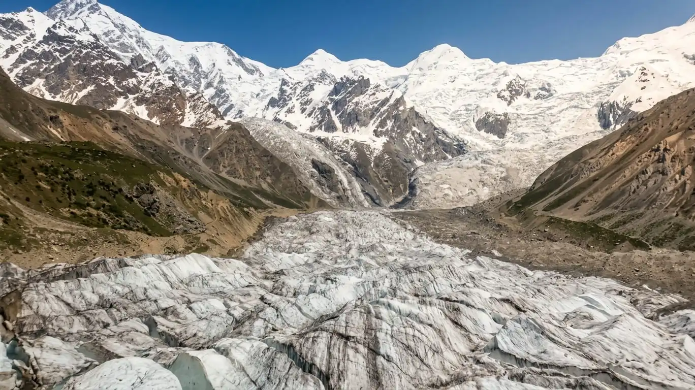
Above the valley, the Diamir Glacier drains the lower slopes of the face and forms part of the route to Base Camp. The approach around it is generally treated as a trekking route rather than a technical climbing route, but snow cover, ice conditions, moraine and crevasse exposure vary with season and recent weather, so it should not be assumed to be risk free simply because it is not roped climbing.
Base Camp itself is generally placed somewhere around 4,200 to 4,250 meters. The figure depends on which expedition account you consult and exactly where a given team pitches camp along the moraine in a particular year, rather than reflecting one fixed official elevation. Camp positions further up the mountain shift for similar reasons, so historical elevations recorded by one expedition should be read as a snapshot of that season’s conditions rather than a permanent marker.
Nanga Parbat’s three major faces are often confused with one another in general writing about the mountain, so it helps to set them side by side.
| Feature | Diamir Face | Rupal Face | Rakhiot Face |
|---|---|---|---|
| Aspect | Northwest | South | North |
| Approach valley | Diamir Valley | Rupal Valley | Fairy Meadows and Rakhiot Valley |
| Established route | Kinshofer Route | Schell Route and other technical lines | Historic 1953 first ascent line |
| General character | Rock, ice and mixed terrain on a buttress line | One of the largest rock and ice walls on Earth | Historically significant, climbed less often today |
| Modern relevance | Standard side for most contemporary expeditions | Fewer attempts, more sustained technical climbing | Occasional historical and trekking interest |
The Rupal Face is frequently cited among the largest mountain faces anywhere because of its vertical scale. The Diamir side, by contrast, has become the side most commonly used for contemporary attempts, largely because its logistics and established line of ascent are comparatively more approachable relative to Rupal’s technical walls. Approachable is a relative term here, not a claim that the route is easy.
The Main Routes on the Diamir Face

The Diamir Face carries several named routes with distinct histories, and treating them as interchangeable does real damage to how differently they actually climb.
The Kinshofer Route
The Kinshofer Route is the established normal route on Nanga Parbat and the line used by most contemporary expeditions on the Diamir side. It follows a buttress rather than the central part of the face, which is exposed to avalanche danger from hanging glaciers, and climbs through difficult terrain associated with the Löw Ice Couloir and Kinshofer Icefield before reaching the higher slopes toward the summit.
The history of the route name is more complicated than a simple connection to the 1962 first ascent. The 1961 Herrligkoffer expedition reconnoitered the Diamir Face to about 7,100 meters, with Toni Kinshofer among the climbers involved. In 1962, Kinshofer, Siegfried Löw and Anderl Mannhardt completed the first ascent from the Diamir side, following the line prepared during the earlier reconnaissance. However, an American Alpine Club correction published in 1984 states that the Kinshofer Weg or Kinshofer Route was first observed and unofficially given that name during Herrligkoffer’s 1963 reconnaissance expedition, of which Kinshofer was a member. Herrligkoffer’s 1975 expedition later attempted the route, and Hanns Schell and his companions successfully climbed it in 1976.
This distinction matters because the 1962 expedition had named specific features on its route, including the Löw Ice Couloir and Kinshofer Icefield. The modern Kinshofer Route therefore developed from the line established by the 1962 ascent but acquired its standard route name through later climbing history. The exact line used today can also vary slightly with snow, ice and rock conditions, so Kinshofer Route is best understood as a general established line rather than one identical track followed every season.
The Messner Route and the Messner Couloir
The Messner Route refers to the new line Reinhold Messner climbed alone in 1978. His ascent line and his separate descent line, generally referred to as the Messner Couloir, are related features of the same climb but are not the same feature, and modern route topos distinguish between them. Some later expeditions, when conditions on the Kinshofer Wall have turned dangerous with rockfall, have shifted onto ground close to the Messner line instead, which is part of why the name still appears in current expedition reports rather than only in historical ones.
The Mummery Rib
The Mummery Rib, also referred to in some sources as the Mummery Spur, marks the line Albert Mummery attempted in 1895, the first serious mountaineering attempt on Nanga Parbat’s west side. Different sources use Rib and Spur somewhat interchangeably for the same general feature rather than describing two separate lines. It has drawn a number of later attempts, some of them fatal, and is regarded as one of the more objectively hazardous features on the face because of rockfall exposure. Reinhold and Günther Messner’s 1970 descent from the Rupal side, discussed below, passed close to this feature on the way down.
Later Variations and New Lines
The Diamir Face has continued to evolve beyond its historic routes. In 2003, Jean Christophe Lafaille and Simone Moro established the 1,400 meter Tom and Martina route in alpine style on a broad buttress left of and parallel to the 1978 Slovak line before joining the Kinshofer Route higher up. In 2022, François Cazzanelli and Pietro Picco created the Aosta Valley Express, a difficult variation that climbed a serac between the Kinshofer Route and lower Mummery Spur before rejoining the established route at Camp 2. These climbs show that the Diamir Face is not simply a choice between one normal route and Messner’s line. Climbers have continued to adapt and develop it in response to conditions and opportunities on the face.
History of Climbing the Diamir Face

The climbing history of the Diamir side reaches back further than casual accounts often suggest, and several of its milestones rank among the most significant in Himalayan mountaineering generally.
1895. Albert Mummery led the first serious attempt on the Diamir side, reaching a high point of around 6,100 meters with his companion Ragobir before retreating when Ragobir became ill. Mummery then moved his effort toward the mountain’s northern side to reconnoiter a pass in the direction of the Rakhiot side. It was there, not during the Diamir attempt itself, that he and two Gurkha companions disappeared and are presumed to have died in an avalanche. The distinction matters: Mummery’s death is tied to a separate reconnaissance on the far side of the mountain, not to his Diamir Face attempt.
The 1930s. With Nepal closed to foreign expeditions, German teams returned repeatedly to Nanga Parbat through this decade, mostly via the Rakhiot side rather than Diamir. These campaigns produced heavy losses, including several climbers and porters killed by a high altitude blizzard during the 1934 expedition, and by the time the mountain was finally climbed in 1953, commonly cited figures put the number of deaths in earlier attempts at around thirty, though exact historical counts vary somewhat between sources.
1953. Hermann Buhl reached the summit alone on July 3, climbing without supplemental oxygen and enduring an unplanned open bivouac near the top. This first ascent took place on the Rakhiot side, not Diamir, but it remains the reference point against which every later achievement on the mountain is measured.
1961. Karl Herrligkoffer led a reconnaissance of the Diamir Face, with Toni Kinshofer and Siegfried Löw pushing a line left of the Mummery Rib to around 7,100 meters before weather forced a retreat. This expedition established the general line that would be climbed successfully the following year.
1962. On June 22, Toni Kinshofer, Siegfried Löw and Anderl Mannhardt reached the summit via the Diamir Face, achieving the mountain’s second ascent overall and the first from this side. A fourth climber, Manfred Sturm, turned back below the final push. The descent turned into an ordeal: the team bivouacked above 8,000 meters without sleeping bags, and Löw, already suffering from frostbite and exhaustion, died during the descent. Kinshofer and Mannhardt survived but lost fingers and toes to severe frostbite. The line they climbed became the Kinshofer Route and remains the mountain’s standard way up, even as later parties have adjusted its exact path in places.
1970. Reinhold and Günther Messner made the first ascent of the Rupal Face, then found themselves unable to safely retrace that route on the way down. They improvised the mountain’s first full traverse, descending instead via the Diamir side on a line passing close to the Mummery Rib. Günther was killed by an avalanche during that descent, a loss that has remained the subject of prolonged and at times contentious historical debate over the exact circumstances and the later discovery of his remains. This should be read as a documented but disputed episode rather than a fully settled account in every detail. It is worth stating plainly that this was not Reinhold Messner’s solo climb, a separate achievement that came eight years later.
1978. Reinhold Messner returned to climb a new route on the Diamir Face entirely alone, without a partner, without supplemental oxygen and without fixed ropes above Base Camp. It is widely recognized as the first solo ascent of an 8,000 meter peak. Messner deliberately avoided the Mummery Rib because of rockfall risk, climbing the line that now carries his name, and descended by a separate route, the Messner Couloir, rather than retracing his ascent line.
2013. In June, a base camp on the Diamir side was attacked by gunmen posing as security personnel. Eleven people were killed, ten foreign climbers and one Pakistani. It remains one of the most serious security incidents in the mountain’s modern history and led to substantially increased security arrangements around later expeditions. Anyone planning travel to the region today should treat security and access conditions as something to verify directly before departure rather than assume from older reporting.
2016. Simone Moro, Alex Txikon and Ali Sadpara completed the first winter ascent of Nanga Parbat on February 26, climbing via the Kinshofer Route on the Diamir side after nearly three decades of unsuccessful winter attempts by other teams.
2025. In July, Denis Urubko and Maria Cardell completed a new alpine style route on the Diamir Face, which they named Nezabudka, Russian for forget me not, after wildflowers growing near Base Camp. They reached the summit on July 10 after roughly five days on the mountain, climbing without fixed ropes, without supplemental oxygen and without support from other climbers on that side of the mountain. Following the announcement, some climbers pointed to similarities between sections of the new line and previously travelled terrain, and independent evaluation of exactly how much of the route was genuinely new ground continued afterward. Reports indicate that higher on the mountain, on the summit pyramid, the pair joined a 1978 variation of the Kinshofer Route originally pioneered by Wilhelm Bauer, Reinhard Streif and Rudolf Wurzer, rather than climbing entirely independent ground all the way to the top. None of this diminishes the significance of the alpine style ascent itself, which is also noted as among the first new lines to an 8,000 meter summit completed in this style with a woman on the rope team, but it is worth stating precisely rather than describing the whole route as untouched terrain.
2026. On June 30, Polish ski mountaineer Andrzej Bargiel completed what has been reported as the first fully continuous ski descent of Nanga Parbat, skiing the Messner Route on the Diamir side. He climbed to the 8,126 meter summit without supplemental oxygen, then descended on skis, navigating a serac barrier that had ended earlier ski attempts on the same line. According to expedition reports, the continuous ski line ended around 4,400 meters, near Camp I, where continuous skiable snow ran out, a vertical descent commonly reported at somewhere between 3,700 and 4,000 meters. The descent was continuous down to that point on the mountain, not a ski run all the way to Base Camp, and it followed a full ascent of the peak rather than standing alone as a separate feat.
Trekking to Diamir Base Camp

Not everyone researching this topic wants to climb an 8,000 meter face, and reaching Diamir Base Camp on foot is a genuinely different undertaking from anything described above.
Access begins from Chilas, reached by road along the Karakoram Highway from Gilgit or Islamabad. From Chilas, jeep tracks and trails lead into the Diamir Valley toward the villages that serve as staging points, and the trek follows the valley upstream, gaining elevation gradually through terraced farmland and grazing land before the terrain shifts to glacial moraine higher up. The character of the walk changes noticeably over the course of the trek, from cultivated slopes near the start to bare rock and ice close to Base Camp.
Published itineraries commonly run somewhere in the range of four to six days round trip, though this should be read as a common pattern rather than a fixed duration. Actual length depends on the operator’s acclimatization schedule, road access conditions in a given year, and whether extra rest days are built in. The lower trail follows established paths through villages and pasture with no technical difficulty. The upper sections cross glacial moraine and, depending on the season, occasional patches of snow, terrain that does not require climbing skills but does demand sturdy footwear, trekking poles and careful footing on loose ground.
This is a demanding high altitude trek, not a casual walk, and it should not be treated as low effort simply because it involves no technical climbing. Reaching Base Camp requires reasonable fitness, a sensible acclimatization schedule, gear suited to cold nights and shifting weather, and realistic expectations about how altitude affects even experienced walkers. Basic logistics worth planning ahead of time include arrangements for a local guide and porters, water and food for a multi day trek away from villages, and camping arrangements once above the last settlements, since fixed accommodation largely disappears past a certain point in the valley. Mobile coverage also becomes unreliable well before Base Camp. Travelers should confirm current permit, registration, access and security requirements directly with operators or relevant authorities before departure rather than relying on older published guidance.
The main trekking and climbing season is broadly the summer months, when conditions in the valley and on the approach tend to be more settled, but mountain weather at this altitude is not fully predictable on a fixed calendar, and conditions can shift quickly regardless of the month. Later summer weeks can bring increased moisture and less stable weather in some years, which is a general tendency rather than a guarantee for any specific trip.
None of this is equivalent to climbing Nanga Parbat. Reaching Base Camp can be done without any intention of going higher, and it involves nothing comparable to the steep snow, ice and rock, the objective hazards, the sustained altitude exposure and the route finding demands that define technical climbing on the face above. The Diamir Face itself, meaning the Kinshofer Route, the Messner Route and the ground between them, requires mountaineering skill, specific equipment, formal permits and full expedition level preparation that share little with the trekking approach. Conflating the two understates what climbers on the face are actually doing.
How Difficult Is the Diamir Face?

Difficulty here means different things depending on the objective, and treating trekking and climbing as one question causes confusion.
For trekkers, reaching Base Camp is a demanding high altitude walk that rewards proper preparation and realistic pacing, where the main challenges are elevation gain, stamina and altitude adjustment rather than technical skill.
For mountaineers, climbing the Diamir Face above Base Camp is a serious undertaking on an 8,000 meter peak, and its difficulty is not fixed. It changes with the specific route chosen, current snow and ice conditions, the season, recent weather, rockfall and avalanche activity on a given day, and a team’s own acclimatization and technical experience. Even on the established Kinshofer Route, climbers face steep ice, mixed rock and ice climbing through the Kinshofer Wall, exposure to rockfall and avalanche from hanging glaciers in the center of the face, and the physiological demands of a summit push above roughly 7,900 meters. Expedition reports across several decades describe falling rock, unstable ice and avalanche hazard on this route with enough consistency that it should be understood as a recurring feature of the climb rather than an isolated event. No single grade or rating captures this reliably, since conditions and route choice both shift the actual difficulty from one season, and sometimes one week, to the next.
Why Is Nanga Parbat Called the Killer Mountain?

The nickname traces to the mountain’s difficult early climbing history rather than to any single event. Repeated German expeditions through the 1930s, mostly on the Rakhiot side, lost climbers and porters to storms, avalanches and altitude related illness, and commonly cited figures place the toll of earlier attempts at around thirty lives by the time Hermann Buhl finally reached the summit in 1953, though exact historical counts vary by source and by what is included in the total.
The Diamir side carries its own chapter in that history, including Löw’s death during the 1962 first ascent, Günther Messner’s death during the 1970 traverse, and the 2013 attack at Base Camp. The nickname reflects a genuine and sustained pattern of danger across the mountain’s history rather than one precise statistic that can be quoted as a definitive death rate, and it should be understood that way rather than as a claim that the mountain is simply the most dangerous peak in the world by some fixed measure.
Is Nanga Parbat Harder Than K2?

This comparison comes up often and rarely has a clean answer. K2 is generally regarded within the mountaineering community as demanding sustained technical climbing across its standard routes, and it carries a well documented reputation for objective danger of its own. Nanga Parbat’s Diamir side combines rockfall and avalanche exposure with route finding challenges that differ in character rather than simply ranking below or above K2 on a single scale.
Reducing either mountain to a single difficulty ranking tends to obscure more than it reveals. Altitude, weather patterns, technical terrain, objective hazard and route specific conditions all vary between the two peaks, and a team’s prior experience with a particular mountain’s terrain often matters as much as any general comparison between them. Experienced climbers tend to treat both as exceptionally serious objectives for different reasons rather than as points on the same ladder.
Frequently Asked Questions
What is the Diamir Face of Nanga Parbat?
It is the northwest face of Nanga Parbat, a wall of roughly 3,500 meters that serves as the mountain’s most commonly used side for contemporary climbing and as the access route for trekkers heading to Base Camp.
Where is the Diamir Face located?
It sits in Diamer District, Gilgit Baltistan, Pakistan, reached via Chilas along the Karakoram Highway, on the northwest side of the Nanga Parbat massif.
What is the normal route on Nanga Parbat?
The Kinshofer Route, on the Diamir Face, is the mountain’s established standard route, first climbed in 1962 and still used by most contemporary expeditions, though its exact path has shifted somewhat over the decades.
Who made the first ascent of the Diamir Face?
Toni Kinshofer, Siegfried Löw and Anderl Mannhardt reached the summit on June 22, 1962. Löw died during the descent, and Kinshofer and Mannhardt both suffered severe frostbite.
Why is it called the Kinshofer Route if the 1962 team made the first ascent?
Kinshofer took part in both the 1961 reconnaissance of this line and the 1962 ascent that completed it, and the name became attached to the route through repeated later use rather than through a single formal act of naming in 1962.
What is the difference between the Messner Route and the Messner Couloir?
The Messner Route is the line Reinhold Messner climbed alone in 1978. The Messner Couloir is the separate line he descended afterward. They are related features from the same climb but are not the same feature.
What is the Mummery Rib?
A rock and ice feature on the Diamir Face that Albert Mummery attempted in 1895, marking the first serious climbing effort on Nanga Parbat’s west side. Some sources call the same feature the Mummery Spur.
Did Mummery die attempting the Diamir Face?
No. Mummery retreated from his Diamir attempt at around 6,100 meters. He later disappeared with two Gurkha companions while reconnoitering a pass on the mountain’s northern side, a separate event from the Diamir attempt itself.
Can Diamir Base Camp be reached without climbing the mountain?
Yes. Reaching Base Camp is a non technical, high altitude trek, though a genuinely demanding one that requires proper fitness, acclimatization and preparation. It does not require mountaineering skills or a climbing permit.
How long does the Diamir Base Camp trek take?
Many published itineraries fall somewhere around four to six days round trip, though the exact duration depends on the operator, the acclimatization plan and road access conditions that season.
What happened on the 2025 Nezabudka route?
Denis Urubko and Maria Cardell completed a new alpine style line on the Diamir Face, summiting on July 10 without fixed ropes or supplemental oxygen. Reports indicate they joined an existing 1978 variation of the Kinshofer Route higher on the mountain rather than climbing entirely new ground all the way to the summit.
What did Andrzej Bargiel achieve on Nanga Parbat in 2026?
On June 30, 2026, he climbed the mountain without supplemental oxygen and then completed what is reported as the first fully continuous ski descent of Nanga Parbat via the Messner Route, skiing down to around 4,400 meters near Camp I, where continuous skiable snow ran out, rather than all the way to Base Camp.


This Post Has 5 Comments