
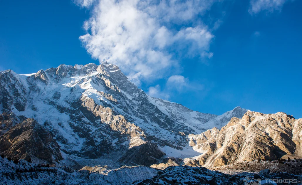
Imagine viewing the world from the ninth-highest mountain in the world, and that too not any ordinary mountain but the majestic Nanga Parbat!
The ‘Killer Mountain’ does not let anyone conquer it easily. As beautiful as this mountain is, it also has an extremely complex ascent. And important to know, that not many people are able to climb this exceptionally breathtaking summit. And, unfortunately, they ended up losing their life.
But even then, this does not scare the madcaps like me. It only heightened my enthusiasm for an ice-climbing trip to the Nanga Parbat. And I was ready for the endless possibilities that I was going to encounter!
Yes, I aimed to climb this challenging mountain!
The divine Nanga Parbat stands proudly at an elevation of 8,126 meters in the Himalayan range of Gilgit Baltistan, Pakistan. And I was ready to land in Pakistan to fulfill my dream.
Necessary Wear and Gear:
Climbing the Naked Mountain safely requires strenuous training, proper gear, and knowing as much as you can about the mountain. As ice climbing is significantly harder than rock climbing, you need to be sure-footed. You need to know the intricate techniques. Moreover, you need to know your way around the technical ice tools. You will have to use them quite frequently on this dangerous but thrilling journey.
Before we started to climb the Nanga Parbat, our porter informed us about the unpredictable weather we were going to experience during our climb. He told us that we needed to prepare for every possibility. We were advised to get sturdy mountaineering boots, with sturdy tools like ice axes, crampons, ropes, harnesses, and protective gear like helmets and goggles. Being aware of the avalanches and the falling ice is necessary. And therefore, a mountaineering guide will be really helpful in that cause.
I packed all my necessities, like warm clothes, appropriate gear, a first aid kit, and a set of ice axes, in my beat-up but fairly serviceable backpack. My family and I flew to Islamabad (the capital of Pakistan) to start our exhilarating journey. From Islamabad, after a brief stay, we rented a jeep to drive through the beautiful roads of Rawalpindi, Chilas. And then, finally, our almost 8-hour drive ended when we reached Halala. There, we retired our jeeps because we had to trek for the rest of our journey.
Trek towards the Nanga Parbat:
From Halala, after resting for an hour or so, we started our one-hour trekking journey to Jheel. The serene lake surrounded by beautiful mountains was truly a remarkable sight. After camping there for a night, we continued to trek for another 4 to 5 hours to reach Kutagali. There we stayed for a day.

From Kutagali, we headed to the breathtaking base camp of the second-highest mountain in Pakistan. Arriving at the base camp raised a lot of excitement and nervousness within me as the whole point of this trip started feeling real. Our first day was spent resting and preparing for the climb.
Ascension on the Nanga Parbat:
The morning after, we began climbing the Nanga Parbat. Ice climbing is extremely tricky, but with the correct strategy and equipment, you can enjoy the climb without worrying about the risks. Even though it was not my friend’s or my first time ice climbing, we still opted to have a Sherpa (local guide) to help us navigate better.
Our mountaineering guide helped us quite a lot by explaining the different positions, like the H position or the C position, in detail. And explained how we have to utilize our energy and acclimatize frequently. We also got briefed about how being excessively energetic will lead us to excessive lactic acid formation. And how it can cause an imbalance in our body’s pH level. Or how even holding your climbing tools too tightly will wear off your arms too soon.
Despite knowing most of the rules, it was helpful to brush up on the knowledge we had about ice climbing. Slowly ascending towards the top with constant breaks, I could see the lush greenery, the enchanting lakes, and the camps on the land. It all seemed to be getting minute by every step we took, it was truly fascinating.
Resting at the base camps at different elevations used to be one of my favorite times of the day. That’s when I get to revel in the beauty of the surrounding mountains, like the Rakhiot Peak, the Ganalo Peak, and many more. There were some days when the extremely cold temperature made our task hard. But thanks to the base camps, they helped us cope with the harsh realities of nature.
On the top of Killer Mountain:
Other than the weather, our climb to the top was pleasing and thrilling. None of us miraculously got injured or got sick as we took our time to acclimatize, and we took as many safety hazards as we could. In our last days at the mountaintop, we were all worn out but so excited about what was ahead of us.

Reaching the top of The Nanga Parbat after almost a month of climbing and camping felt liberating. But then, seeing hundreds of miles below me and the surrounding peaks was enchanting. The Rakhiot Peak, 7,070 meters, Chongra-I, and Ganalo Peak, encapsulated the Nanga Parbat, making the scenery better than I could ever have imagined!
Descent from Nanga Parbat:
Descending the mountain also went smoothly without any problems. From the Nanga Parbat base camp, we trekked back to Jheel and then to Halala. There we rented a jeep again and drove back to Islamabad via Chilas to fly back home.
Though climbing Killer Mountain came with a lot of risk, it still turned out to be one of the best climbs I have ever experienced. The beauty we got to witness was beyond anything words can describe.
So, with enough training, an experienced guide, and appropriate gear, you can have the best time of your life while climbing the majestic Nanga Parbat!
Here is a guide to Nanga Parbat, to help you navigate safely through the gruelling routes of the mountain:
A Guide to Nanga Parbat: All You Need to Know About the Killer Mountain


