
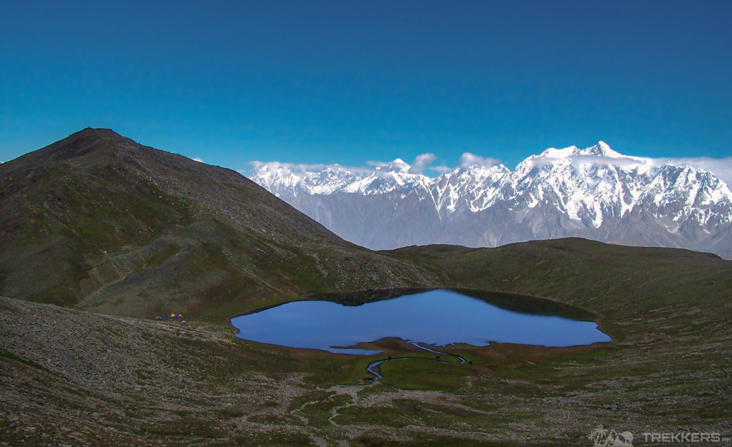
Rush Lake is a popular tourist attraction located in Hunza Nagar, Gilgit Baltistan, near Rush peak which is 4,694 meters high. The lake is situated at 4,694 meters, which makes it one of the highest alpine lakes in the world!
Rush Lake translates to sparkling Lake. It is one of the most recommended treks for first-time trekkers. As it is an easier trek with magnificent scenery.
I have always been fascinated by the northern side of Pakistan. So for our annual sibling trip, we decided to travel to Hunza and have a trekking expedition to Rush Lake.
Our journey started when we landed in Islamabad. The tour company we hired provided us with a car to help us travel to our next stop.
My experience of traveling from Islamabad to Barichokore was filled with both, delight and wonder. The astounding landscapes of these destinations such as the beautiful landmarks of Chillas, Karimabad, and Hopper. The extremely pleasant weather which was perfect for the tour season.
Our trekking journey started when we reached Barichokore. We took a step to eat our lunch provided by our tour company. The environment there was majestic because of the greenery and other beautiful landmarks. The trek took us 5 hours to complete as it was 3,300 meters long. After the trek, we decided to make most of the stunning surroundings and decided to camp overnight amidst the astonishing scenery.
After our overnight stay at Barichokore, we continued our thrilling journey and started trekking towards Chidin Harai. We took multiple stops during the trek as it was almost six hours long (4,440 meters). Stopping and reveling in the beauty of nature was one of my favorite parts of the trip.
Next morning, we continued trekking for approximately 3 hours after having our breakfast and after our beautiful trek, we finally arrived at our main destination, the enchanting Rush Lake.

It is located about 15 km north of Milar Peak and Spatnik (Golden Peak) in the Nagar Valley. It is one of the highest lakes in Pakistan and the 27th highest lake in the world. I was overwhelmed by the view before my eyes. The lake was stunning and nestled in the mesmerizing landscapes there. It was a picturesque setting with crystal-clear, surrounded by magnificent mountains. The beauty of the lake was simply breathtaking.
We had the privilege to walk on the glaciers there, through the villages to look at the real life of those living so close to these mighty glaciers. The whole experience was extremely fascinating. The lake is a junction between two famous glaciers; Barpu and Bualter and the locals there believe in a legend about those two glaciers being male and female. They also talk about the two glaciers meeting and the birth of new glaciers.
My siblings spontaneously decided to hike the Rush Peak and how could I deny this once in a lifetime experience? We got our hiking gear and continued with our journey to climb the Rush Peak.
Rush Peak is a mountain in the Karakoram Mountain range. While not a high peak by local standards, it is remarkable as a remote trekking destination. It is 5,560 meters high, and the peak was easy to climb as we took our trip during summer, hence no heavy snow.
The view from the peak was beyond description. We could view the majestic Miar Peak (6,824 m), Miar glacier, and Phuparash Peak (6,574 m). The snow-capped mountains from the top looked ravishing. The locals also told us about how on a clear day you can view the world’s highest mountains, including K2 and Broad Peak.
After basking in the beauty of Rush Lake and camping there for a night we reluctantly packed our tent and proceeded with our trek. As the last stops were coming, we felt both excitement and sadness but mostly contempt as I thought about the everlasting memories we created on this trip.
From Rush Lake we trekked towards Phyphary and Hamdar. There, we took a break to eat and fueled up ourselves for our remaining journey. From Hamdar we trekked for 4 to 5 hours to reach Hopper. We visited the marvelous green fields and vibrant fruit orchards which are also famous for their potato seeds that are exported to other parts of Pakistan, especially in Northern areas.
From Hopper, we drove back to Karimabad where we got to visit the beautiful Altit-Baltit Forts and the enchanting Duiker valley. After an overnight stay we took an excursion to the Khunjerab pass (4,733 m). From Karimabad we drove to Naran via Babusar pass (4,173 m) and then reached Islamabad after a 6-to-7-hour drive via Taxilla. After an overnight stay in Islamabad, we flew back home.
This trip was a blissful experience and will forever stay with me. Coming to Naran, Pakistan was one of the best decisions I have ever made and it made me fall in love with the beauty of Pakistan!


