
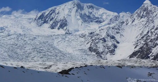
Many tourists and adventurers are drawn to Passu Sar, where they can either conquer its difficult peak or just enjoy its magnificent presence. A constant stream of climbers pushing the boundaries of their abilities to reach this difficult summit can be seen ascending it.
Beyond its appeal to mountaineers, Passu Sar is tucked away in the breathtaking Hunza Basin. The basin, well-known for its enduring customs and rich cultural legacy, presents a mosaic of various cultures just waiting to be discovered. The surrounding villages, each providing a unique window into their own distinctive customs and way of life, add to the allure. Travel to Passu Sar and experience the alluring fusion of cultural treasure and natural wonder.

Passu Sar, an attractive peak that surrounds steep, rocky, and difficult paths. It is elevated at a stupendous height of 7,478 meters in the Batura Muztagh, a sub-range of the Karakoram Mountains. Despite all this, its beauty never fails to impress tourists and climbers who come to visit it.
Trek to Passu Sar:
Passu Sar is a well-recognized destination that has been gaining importance among passionate mountaineers. It has possessed an enthusiastic approach for a long time. This incredible field is known to be home to the world’s tallest peaks. It offers magnificent trails that can accommodate a unique and incomparable experience of biking.
Along with Passu Sar, one of the known best routes is the Passu Berg trail, which offers an attractive viewpoint of the glacier. This route is as treacherous as its neighbouring peaks. The walkway is laborious due to its rough incline and a landscape full of stones. Also, it is tough to achieve the highest top. In addition to this, a prominent alley ahead of Passu Sar is the Batura Berg trail. It is spread over 56 kilometers. The region gives unbelievable opportunities to observe and explore the beauty of Gilgit Baltistan.
Somewhat less demanding trail routes to Attabad Lake are fewer challenging trails. The trail is comparatively smooth and goes through a variety of landscapes and traditional villages. It provides the wanderers with an incredible view of the cultural aspects of Gilgit-Baltistan.
Furthermore, near Passu Sar, another important visit trail leads to Khunjereb Pass. It is known to be Pakistan’s horizontal cross-over of the international border. This route offers a fascinating mixture of natural and historical perspectives. This road takes us towards some of the most spectacular landscapes of Pakistan.
Whether you are a hiker looking for adventurous challenges or a novice hiker who is fond of natural beauty. You can have innumerable experiences with the trails near Passu Sar in Gilgit-Baltistan. These roads provide chances to explore the magnificent mountainous territory. It also brings a huge insight into prosperous traditions and civilization.
Expedition Tale to Pasu Sar:

I began to start my journey for the Pasu Sar, which is part of the Muztag Sub range. It is located within the Karakoram Range. It can be seen very close to the well-known peaks of Shispare and Ultar Sar. I saw that this peak has attracted mountaineers and climbers from around the world. The reason is its challenging climbs and height. The region that surrounded the Pasu Sar attracted me. It was really bewitching because of the beautiful and stunning horizons and views. It includes the glaciers and other heightened surrounding nature. Climbing over the Pasu Sar required me to use my technical climbing skills. It compelled me to be mentally ready for an adventurous environment.
Challenges Faced During the Climb:
The climbing itself is a big challenge. There are many ice walls and crevasses between Base Camp and Camp 1 and close to Camp One. One needs to find the exact route. This is something that we did as well to climb with our team. It takes a lot of time to search for the exact route through the ice walls and crevasses. There is also a large rope required, which should be at least 500 to 700 m. But it still depends on how many members are there in the group. We also carried two ladders in case the crevasses became bigger.
I found Pasu Sar Peak challenging to climb. It indeed was a very technical, rocky, and steep peak in the region. This is the reason many climbers find it hard to climb and are also not willing to go for it. The weather is harsh, and it adds to the difficulties of this peak. However, despite all these difficulties, Pasu Sar attracts many visitors and climbers. And the climbers come to this peak to test themselves and their skills.
I came across another amazing feature of this Pasu Sar: its sharp ridgeline. It is also jagged and can be seen from far away. The eastern face of the peak is very beautiful. It is attractive, with a steep and rocky, sloppy height that comes vertically from the summit.
Conclusion:
The experience of Pasu Sar was indeed a roller coaster of fun and adventure all together. The peak gave me real pleasure, and its beauty surrounding different areas was a pleasure to visit as well. The visit also gave me a perception to look at nature from a different point of view. Nature can be beautiful and adventurous at the same time.


This Post Has 2 Comments